From Pixels to Proof: Using Satellite Imagery as Evidence of War Crimes

Created by: Benjamin Crane
June 1st, 2026
Purpose
This study investigates the evolving role of satellite imagery in modern conflict zones, specifically examining its transition from a scientific monitoring tool to a primary instrument for war crime identification and ethical documentation. By analyzing the environmental and infrastructural impacts in Kherson Oblast following the Kakhovka Dam breach, this research explores how remote sensing data serves as critical evidence for potential war crimes and crimes against humanity. Ultimately, this analysis seeks to evaluate who maintains access to these high-resolution perspectives, the ethical considerations governing their distribution, and the broader implications of using geospatial intelligence to quantify the human and ecological costs of conflict.
Area of Interest: Ukraine and the Kherson Oblast Region
Ukraine is the largest country located entirely within Europe, characterized primarily by fertile lowlands and vast steppes, with the Dnipro River serving as a vital geographic and economic artery. This analysis focuses on Kherson Oblast in Southern Ukraine, a region of immense agricultural importance and strategic value in the ongoing Ukraine conflict.
The area is home to critical infrastructure, including the Kakhovka Dam, whose breach in June 2023 caused catastrophic flooding. Concentrating on both the national scale and specific administrative boundaries of Kherson, this study quantitatively assesses the environmental impact of the breach and how satellite imagery may be used to identify war crimes and/or crimes against humanity.
Background
Infrastructural Significance and the Geopolitics of the Kakhovka Reservoir
Situated along the Dnipro River in southern Ukraine, the Kakhovka Reservoir
serves as a critical node for regional survival and strategic energy production. Extending approximately 150 miles, the reservoir historically supported the Nova Kakhovka Hydroelectric Power Plant and provided essential cooling water for the Zaporizhzhia Nuclear Power Plant to the north. Prior to the 2023 catastrophe, the reservoir functioned as the primary artery for potable water and electrical power for millions of residents across Southern Ukraine and Northern Crimea.
Constructed in 1956, the Nova Kakhovka Hydroelectric Power Plant represented a vital industrial asset, generating 1.4 Terawatt hours of electricity annually. The reservoir itself held an estimated 18 cubic kilometers of water—a volume comparable to the Great Salt Lake in Utah—underlining its status as an indispensable hydrological resource for the region's agricultural and urban stability.
Strategic Occupation and the Breach of June 2023
The strategic landscape shifted significantly in February 2022 when Russian forces seized control of the dam and its associated power facilities. By October 2022, Ukrainian leadership, including President Volodymyr Zelenskyy, began documenting evidence suggesting the infrastructure had been mined. These warnings preceded the eventual structural failure on June 6, 2023, when the dam's foundation was breached following a period where water levels had been permitted to reach maximum capacity, further straining the 30-meter structure.
The resulting breach triggered an immediate and catastrophic inundation of the Dnipro's downstream basin. Beyond the physical destruction of over 40 towns and villages, the event effectively dissolved the geographic and tactical borders established by the river. The floodwaters rendered terrestrial transportation impossible, forcing a transition to maritime logistics for months while simultaneously erasing the physical demarcations of territory.

Post-Disaster Quantifications
To address the human and ecological costs, the Ukrainian government, in coordination with the United Nations, initiated a Post-Disaster Needs Assessment. This report serves as a foundational dataset for this study, providing an economic and environmental ledger of losses across the agricultural, infrastructural, and ecological sectors. By synthesizing these UN-verified statistics with geospatial analysis, this research aims to identify critical recovery zones and prioritize the allocation of reconstruction resources within the long-term stabilization framework.
Change Detection using Sentinel-2 Satellite Data
This analysis compares data from Sentinel-1 & 2 images of two temporal periods (2022 and 2023), comparing the whole country of Ukraine and the Kherson Oblast province, to detect changes. The Near-Infrared (B8) band is used for this analysis as it is sensitive to vegetation presence and health.
Methods
Normalized Difference Vegetation Index (NDVI)
NDVI is a graphical indicator that can be used to analyze remote sensing measurements, often from a satellite platform, assessing whether the target being observed contains live green vegetation and to what extent.
The formula for NDVI is: (NIR - Red) / (NIR + Red)
* NIR (Near-Infrared): Reflects strongly off healthy vegetation.
* Red: Absorbed by healthy vegetation for photosynthesis.
Interpreting NDVI values:
* Values closer to +1 (brown on the map): Indicate dense, healthy vegetation (e.g., forests, lush crops).
* Values around 0 (yellow on the map): Suggest sparse vegetation, senescent vegetation, or areas with bare soil.
* Values closer to -1 (green on the map): Typically representing non-vegetated features like water bodies, urban areas, or bare rock, where red reflectance is higher than NIR.


Statistical Difference between NDVI 2022 and NDVI 2023
This is the pixel-wise difference between the NDVI 2022 and 2023 across the country of Ukraine. Positive values indicate an increase in vegetation health (higher NDVI) in 2023 compared to 2022, while negative values indicate a decrease. This analysis computes summary statistics for this difference across the country and provides a histogram to further visualize the temporal difference.

Interpretation of NDVI Difference Statistics
*Minimum Difference (-0.7976): This indicates the most significant decrease in NDVI observed in any single pixel within the AOI from 2022 to 2023. A value close to -1 often suggests a transition from vegetated to non-vegetated areas (e.g., water, bare land, urban development, or significant damage).
*Maximum Difference (1.0353): This shows the largest increase in NDVI in a single pixel. A value around +1 can indicate a substantial increase in healthy green vegetation, potentially from barren land to dense vegetation, or from water to vegetated areas.
* Mean Difference (0.0262): This positive mean suggests that, on average, there was a slight overall increase in vegetation health across the entire Area of Interest (Ukraine) from 2022 to 2023. This average value smooths out local variations, indicating a general trend.
*Standard Deviation (0.1072): The standard deviation measures the spread or variability of the NDVI differences. A value of 0.1072 indicates a moderate amount of variation in NDVI changes across the region. This means that while there's a slight average increase, there are considerable areas with both decreases and more substantial increases in vegetation health, not a uniform change across the entire country.
What Does This Mean?
While the NDVI change data for all of Ukraine shows a positive change in green vegetation it does not tell the whole story. The Kherson Oblast province had been affected by attacks on infrastructure. The destruction of the Kakhovka dam in June of 2023 flooded the surrounding area and devastated immediate communities. We will now look specifically at the Kherson Oblast Province.
NDVI Change Detection for Kherson Oblast (2022 vs 2023)
This section focuses on the NDVI change detection analysis using the precisely defined Kherson Oblast region geometry. The process involves re-running the composite creation and NDVI calculation steps for this specific region to compute and visualize the difference.
NDVI maps for Kherson Oblast

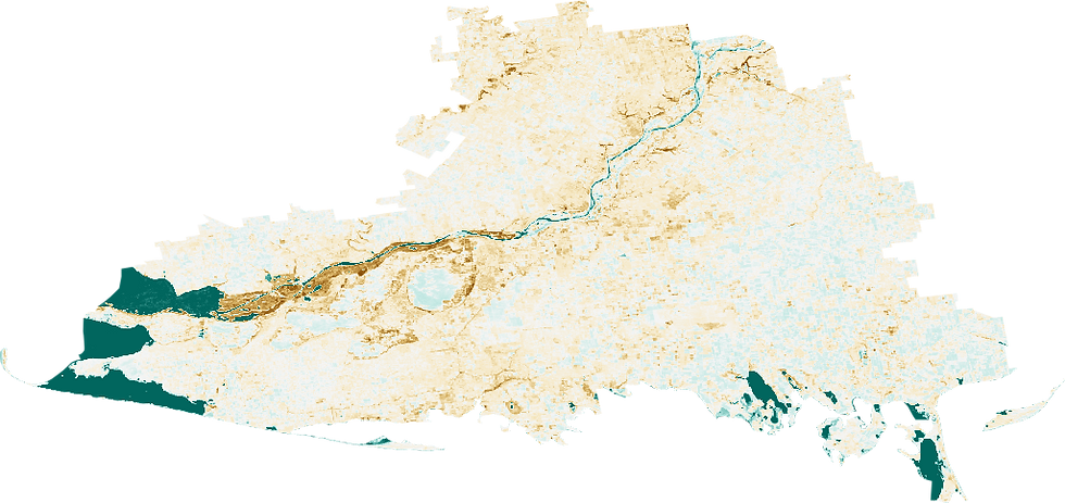
NDVI Change map (2022 - 2023) for Kherson Oblast

Statistical Summary of NDVI Change in Kherson Oblast
The summary statistics and NDVI of the Kherson Oblast province and a histogram to further visualize the temporal difference.

Interpreting the NDVI Change for Kherson Oblast (2022 vs 2023)
The NDVI Change Map for Kherson Oblast visually depicts areas of increased and decreased vegetation health between 2022 and 2023, while the statistics provide a quantitative summary of these changes.
Key Findings from the Map and Statistics:
* Minimum Difference (-0.7976): This value indicates a significant reduction in vegetation health in specific areas. In the context of the Kakhovka Dam breach in June 2023, these negative values likely correspond to inundated zones or destroyed agricultural land where green vegetation was replaced by water or debris.
* Maximum Difference (0.9354): This positive change signifies a substantial increase in vegetation health in other parts of the oblast. A value reaching 1.0 suggests a transition from non-vegetated (perhaps seasonal fallow or water) to dense green vegetation, or potentially rapid weed growth in areas where floodwaters receded.
* Mean Difference (-0.0212): Interestingly, despite the localized catastrophe, the mean difference for the entire Kherson Oblast is slightly positive. This suggests that while specific zones suffered extreme loss, other parts of the region may have seen stable or improved vegetation health due to seasonal factors or agricultural shifts elsewhere in the province.
* Standard Deviation (0.1195): This measures the variability of the NDVI changes. This level of variation is expected in a region experiencing major environmental shock, where some areas are devastated by flooding while others remain unaffected or show significant regrowth.
This analysis clearly shows that while the average change might be slightly positive, there are significant localized impacts on vegetation health across the Kherson Oblast, directly attributable to the Kakhovka Dam breach and ongoing conflict.
Statistical Confidence & Error Analysis
To evaluate the reliability of the Mean NDVI Change, we calculate the potential error levels based on the standard deviation and the sample size (N=5000 for Ukraine, N=2500 for Kherson).
1. Standard Error (SE):
Ukraine: With a standard deviation of 0.1072, the Standard Error of the mean is approximately *0.0015**.
Kherson Oblast: With a standard deviation of 0.1195, the Standard Error of the mean is approximately *0.0024**.
2. Confidence Intervals (95%):
* Ukraine Mean (+0.0262): The 95% confidence interval is [0.0232, 0.0292]. Since this interval is entirely above zero, the recorded increase in vegetation at a national level is statistically significant.
* Kherson Mean (-0.0212): The 95% confidence interval is [-0.0259, -0.0165]. This interval is entirely below zero, confirming with high statistical confidence that the region experienced a net decrease in vegetation health.
3. Analysis of Variance:
While the mean changes appear small, there are many standard errors away from zero. This indicates that the divergence between the national 'green-up' trend and the Kherson 'loss' trend is not due to random sampling error but reflects a distinct environmental impact in the Kherson region.
Kakhovka Dam Breach Assessment & Potential War Crimes
Report Summary & Project Context
The UN Rapid Environmental Assessment of the Kakhovka Dam breach (June 2023) describes the event as a 'far-reaching environmental catastrophe' that transcends local impacts, affecting the global food supply and ecosystems far into the Black Sea. This aligns with the NDVI analysis of Kherson Oblast performed in this study, which recorded a significant minimum difference of -0.7976, quantitatively capturing the 'massive flooding' and 'total loss of vegetation' cited in the report.
According to the United Nations Environmental Protections (UNEP) assessment, the breach on 6 June 2023 led to extensive and severe environmental damage across Kherson Oblast and beyond. Key impacts include:
* Widespread Flooding and Devastation:
Hundreds of square kilometers were

flooded downstream, while thousands of square kilometers of the Kakhovka reservoir and its surrounding wetlands were desiccated. This transformation rapidly converted a mature aquatic ecosystem into a nascent riverine environment, with much of the damage to this area being highly likely irreversible.
* Ecosystem Destruction: Protected areas, such as the Velykyi Luh National Nature Park, were entirely damaged due to their reliance on water conditions. Groundwater levels have fallen, leading to subsidence, and the damage to local ecosystems is expected to have substantial and potentially permanent impacts, particularly for communities dependent on the reservoir for drinking water and irrigation.
* Habitat Loss and Pollution: Downstream, the high-velocity flood caused significant losses in natural habitats, plant communities, and species, including the inundation of approximately 12,000 hectares of forest. There was a confirmed release of chemical pollutants, such as machine oil and liquid fertilizer, with 54 identified 'pollution hotspots' in the flood zone. Sediment deposits, potentially containing increased levels of heavy metals, hydrocarbons, pesticides, and other pollutants, also pose risks to the environment and human health.
* Hindered Assessment by Conflict: The assessment noted that the disaster unfolded on the frontline of the war, making direct access to affected territories difficult or impossible due to mines, shelling, and military combat. This lack of first-hand data complicated the confident prediction and full understanding of the environmental impacts.
These findings underline the profound and multifaceted environmental devastation caused by the Kakhovka Dam breach, making it one of the most significant environmental damages of the war in Ukraine. The observed NDVI loss serves as a measurable indicator of this catastrophe, providing critical evidence for environmental accountability.
Crimes Against Humanity in Kherson Oblast (OHCHR Findings)
In addition to the environmental destruction of the Kakhovka Dam, investigations by the Office of the United Nations High Commissioner for Human Rights (OHCHR) have identified a systematic pattern of crimes against humanity committed by Russian authorities in Kherson Oblast. The report highlights that civilians were targeted through widespread and systematic attacks, including:
* Targeting of Civilian Infrastructure: Deliberate strikes on energy, water, and heating facilities, which the UN states were intended to 'terrorize' the civilian population.
* Enforced Disappearances and Torture: Detailed accounts of arbitrary detention and the use of torture against local officials, activists, and civilians perceived as pro-Ukrainian during the occupation of Kherson city and the surrounding Oblast.
* Deportation of Children: The forcible transfer and deportation of Ukrainian children to Russian-controlled territories, which constitutes a grave violation of international humanitarian law.
These findings suggest that the environmental impacts observed via satellite imagery (such as the loss of agricultural productivity and flooding) occurred within a broader context of intentional civilian harm, fitting the legal threshold for crimes against humanity due to their widespread and systematic nature.
Ethics
Having access to satellite imagery is having access to a view of Earth no generation possessed before 1959. The first Landsat images were acquired from the 1972 NASA/USGS satellite launch, and numerous missions since have expanded our ability to visualize and analyze the planet. With this capability comes the responsibility of ethical use and distribution. While some governments retain classified imagery, agencies like the European Space Agency (ESA) provide open access for scientific and cultural purposes. However, ethical responsibility does not end with accessibility extending to how imagery is interpreted, framed, and shared.
Use of Satellite imagery is not neutral. The way analysts select data, define thresholds, and interpret patterns shapes the narratives that emerge. This raises important questions of power and representation: those producing and analyzing the imagery often have more influence than the communities being observed. Incorporating local context and acknowledging these imbalances is essential to ensure that analysis does not overlook or misrepresent lived experiences.
Accountability and Evidence
In the context of the Ukraine conflict, satellite imagery has transitioned from a scientific tool to a source of legal and political evidence. In the analysis of Kherson Oblast, NDVI loss provides measurable indicators of environmental damage following the Kakhovka Dam breach. Such data can support accountability for potential war crimes, aligning with international legal frameworks.
However, this use also requires caution. Indicators like NDVI are proxies, not direct observations, and may be influenced by seasonal variation or other environmental factors. Failing to communicate these uncertainties risks misinterpretation or misuse. Ethical analysis therefore requires transparency about methods, assumptions, and limitations.
When imagery confirms widespread destruction of civilian infrastructure or ecosystems, it can amplify the experiences of affected populations. At the same time, releasing or framing this information carries risks, including political weaponization or oversimplification of complex events. Analysts must remain aware of their role in shaping interpretations and ensure that data is communicated responsibly, with attention to uncertainty, context, and potential impacts on vulnerable populations.
Conclusion
This study has demonstrated the critical role of satellite imagery in documenting and analyzing the environmental impact of conflicts, specifically focusing on the Kakhovka Dam breach in Kherson Oblast. By leveraging Sentinel-1 and Sentinel-2 data, we quantified the significant decrease in vegetation health, supporting the findings of the UN Rapid Environmental Assessment regarding the 'far-reaching environmental catastrophe.' The statistical analysis confirmed a localized, statistically significant decline in NDVI within Kherson Oblast, contrasting with the broader national trend. This highlights the power of geospatial intelligence as primary evidence for potential war crimes and crimes against humanity, emphasizing the ethical responsibilities inherent in its interpretation and dissemination. The observable environmental devastation in Kherson, coupled with the OHCHR's findings of systematic attacks on civilian infrastructure, paints a stark picture of the human and ecological costs of conflict, underscoring the urgent need for accountability and responsible data utilization. Moreover, this analytical framework is crucial not only for documenting current atrocities but also for establishing precedents and methodologies to identify and investigate similar crimes in future conflicts, emphasizing the long-term relevance of satellite imagery in international humanitarian law and environmental justice.
Included Datasets:
* ArcGIS Living Atlas of the World. (n.d.). Raster and vector data. Retrieved from https://livingatlas.arcgis.com/en/browse/?q=Ukraine#q=Ukraine&d=2
* Copernicus Data Space Ecosystem. (n.d.). Copernicus Sentinel Missions. Retrieved from https://dataspace.copernicus.eu/data-collections/copernicus-sentinel-missions/sentinel-2
* EOX IT Services GmbH. (n.d.). Sentinel-2 cloudless - S2 Maps. Retrieved from https://s2maps.eu/
* European Space Agency. (n.d.). Copernicus Sentinel-2. Retrieved from https://www.esa.int/Applications/Observing_the_Earth/Copernicus/Sentinel-2
* Google Earth Engine. (2017). USDOS/LSIB_SIMPLE/2017: Large Scale International Boundary Polygons, Simplified. Retrieved from https://developers.google.com/earth-engine/datasets/catalog/USDOS_LSIB_SIMPLE_2017#description
* Google Earth Engine. (n.d.). COPERNICUS/S1_GRD: Sentinel-1 & 2 Data. Retrieved from https://developers.google.com/earth-engine/datasets/catalog/COPERNICUS_S1_GRD
* Humanitarian Data Exchange. (n.d.). Publicly accessible datasets. Retrieved from https://data.humdata.org/dataset/?ext_geodata=1&groups=ukr&page=3, https://data.humdata.org/dataset/cod-ab-ukr
Related articles:
National Library of Medicine. (n.d.). [Title of specific article if known]. PMC*. Retrieved from https://pmc.ncbi.nlm.nih.gov/articles/PMC10291284/
Global Investigative Journalism Network. (n.d.). How radar satellite analysis reveals changes consistent with military buildup*. Retrieved from https://gijn.org/stories/gijc25-satellite-imagery-investigate-war-crimes/#:~:text=She%20described%20how%20radar%20satellite,changes%20consistent%20with%20military%20buildup.
Nature.com. (n.d.). [Title of specific article if known]. Nature Portfolio*. Retrieved from https://www.nature.com/articles/s43247-025-02183-7
American Association for the Advancement of Science. (n.d.). Satellite imagery assessment crisis Ukraine part two border deployments*. Retrieved from https://www.aaas.org/resources/satellite-imagery-assessment-crisis-ukraine-part-two-border-deployments
UNITS. (n.d.). UNESCO and UN Satellite Centre join forces to safeguard Ukraine's cultural heritage geospatial*. Retrieved from https://unitar.org/about/news-stories/news/unesco-and-un-satellite-centre-join-forces-safeguard-ukraines-cultural-heritage-geospatial
Esri StoryMaps. (n.d.). History of Satellite Imagery*. Retrieved from https://storymaps.arcgis.com/stories/eb19cef2fd9848f1adfa15f2fe5c732a
United Nations Environment Programme. (2023). UN Rapid Environmental Assessment of Kakhovka Dam Breach Ukraine, 2023*. UNEP. Retrieved from https://wedocs.unep.org/handle/20.500.11822/43696
Wikipedia. (n.d.). Indiscriminate attack*. Retrieved from https://en.wikipedia.org/wiki/Indiscriminate_attack


Comments